
About Phase 2
Running from January 23 to February 10, Phase 2 of the reImagining process was designed to give area residents a chance to provide feedback on initial design concepts for the former Highland Golf Course site. With the completion of Phase 2, the project team is now reviewing community feedback and developing one refined concept.
During Phase 3, the community will have a chance to review this refined concept and provide additional feedback.
Understanding the design concepts
In reviewing the design concepts for the site, it’s important to understand the various factors that affect the planning and redevelopment process.
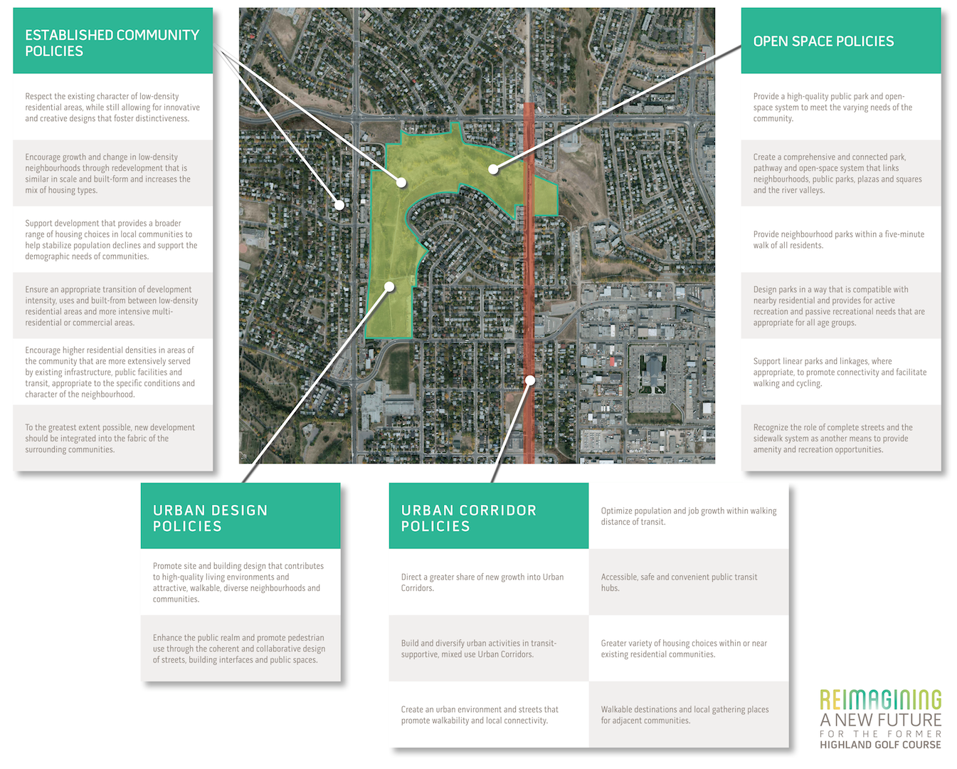
Guiding Policies
In developing the initial site concepts, the project team incorporated guidelines from several government policies. In Calgary, the Municipal Development Plan (MDP) and Calgary Transportation Plan (CTP) are the guiding policy documents for the site.
Four key policy areas have helped shape the initial design concepts:
Open Space
- high-quality public parks and open spaces that meet community needs
- parks, pathways and open spaces that connect people and places
- neighbourhood parks within a five-minute walk of all residents
- design parks for active and passive recreation for all age groups, in a way that is compatible for nearby residences
- support linear parks and linkages that promote connectivity, walking and cycling
- recognize complete streets and sidewalks as a way to access amenities and recreation
Established Communities
- respect existing character of low-density residential areas while allowing innovative and creative designs that foster distinctiveness
- encourage growth and change in low-density neighbourhoods that is similar in scale and built-form and increases the mix of housing types
- provide broader range of housing choices to help stabilize population declines and support demographic needs
- ensure appropriate transition of development intensity, uses and built-form between low-desnity residential areas and more intensive multi-residential or commercial areas
- encourage higher residential densities that are appropriate to neighbourhood conditions and character in areas that are more extensively served by existing infrastructure, public facilities and transit
- integrate into fabric of surrounding community
Urban Design
- promote site and building design that contributes to high-quality living environments and attractive, walkable, diverse neighbourhoods and communities
- enhance public realm and promote pedestrian use through coherent and collaborative design of streets, building interfaces and public spaces
Urban Corridor
- direct greater share of new growth into Urban Corridors
- build and diversity urban activities in transit-supportive, mixed-use Urban Corridors
- create an urban environment and streets that promote walkability and local connectivity
- optimize population and job growth within walking distance of transit
- provide accessible, safe and convenient public transit hubs
- provide greater variety of housing choices within or near existing communities
- provide walkable destinations and local gathering places for adjacent communities
(click image below to expand)
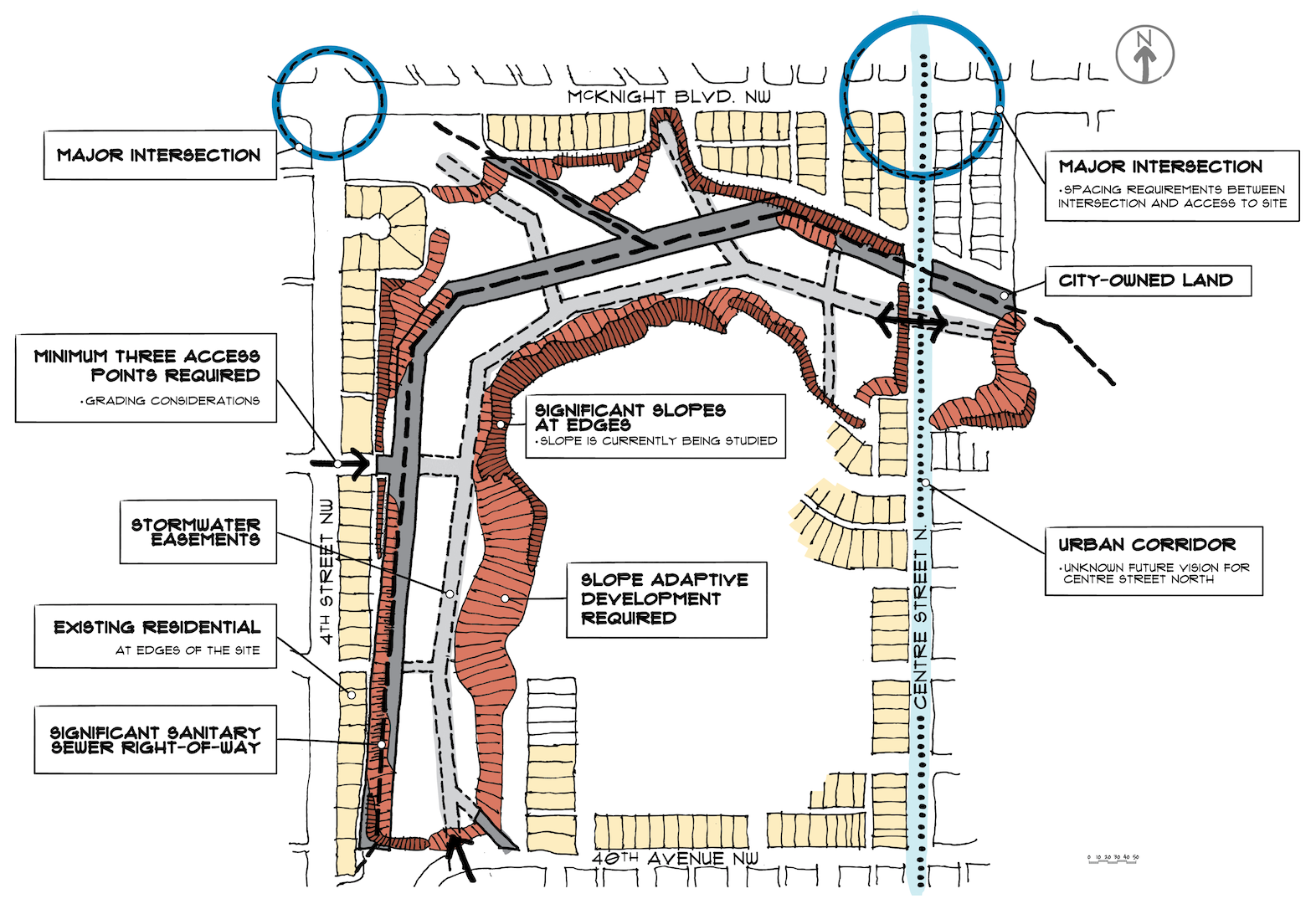
Practical Realities
The site has several significant design challenges, based on its past use, as well as easement and infrastructure elements that extend beyond the site into the community.
Key considerations include:
The City owns a portion of the lands within the former golf course for a significant sanitary sewer line.
Challenge: The location of the line restricts the ability to develop the lands comprehensively, and limits the location of buildings, trees and other features.
There are a significant number of utility easements crossing the lands.
Challenge: The location of these additional utility lines also restricts the ability to develop the lands comprehensively, and will limit the location of buildings, trees and other features.
The site has significant slopes and has had un-compacted fill placed in some areas over the years.
Challenge: The slopes and fill areas require additional study and slope adaptive development policies will apply.
Municipal Reserve (open space) will be required on the lands.
Challenge: To provide functional open spaces for the community while accommodating easements and slope considerations.
The site is in a depression relative to surrounding lands, limiting choices for storm water drainage design.
Challenge: Part of the site will need to be filled and raised in order to meet City of Calgary guidelines. The storm water plan must provide a variety of drainage measures to manage run-off throughout the site, and could potentially leverage opportunities to integrate drainage features in the open space system.
A minimum of three access points will be required to support vehicle and emergency access for the development area. It is also desirable to provide a continuous road network, without dead-ends.
Challenge: Access points to surrounding roadways are limited in some cases due to steep grades, abrupt elevation changes, and the short distances to existing intersections. Access is not desirable through the existing local streets in Highland Park.
The Municipal Development Plan indicates an Urban Corridor along Centre Street.
Challenge: The City of Calgary is continuing to work on future plans for transit corridors in north Calgary. The site will need to be planned to accommodate a variety of different options on the Centre Street corridor.
The site is located within an established community. Boundary roads such as 4 Street NW, 40 Avenue NW, Centre Street N and McKnight Boulevard are shared with adjacent communities.
Challenge: To sensitively integrate new infill development into an established area, bringing benefits to both new and existing residents.
(click image below to expand)
Recent comments